The irony is that 85 years ago, when Mrs. Foster first moved into her home, the busy intersection recently named in her honor was little more than a place to make a turn; anyone traveling between Athens or Monroe and Atlanta had to go through Grayson.
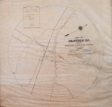
That the Road to Atlanta passed through Grayson is evidenced by one of the artifacts on display at the Arts and History Center– a 1911 map of Grayson showing the city’s electric lighting system. It provides a good bit of insight into the travel patterns of the early 20th Century. Although the map shows the Grayson of 1911 was a far cry from the city it is now, the precursors of today’s roads were in place.
Those roads intersected in the center of Grayson and they follow substantially the same routes today. All are identified by the city to which they connected. What is now Georgia Highway 20 was labeled Lawrenceville Road heading northwest and Monroe Road headed southeast. The road that became Highway 84 (also known as Grayson Parkway, was then labeled Stone Mountain Road and Grayson New Hope Road was then identified as Dacula Road. Considering Grayson’s small population at the time, the road names establish that travelers passed through Grayson when journeying to Stone Mountain and Lawrenceville from points east, and to Dacula and Monroe from points west.
That pattern remained until the late 1930s. By that time, the roads leaving Grayson had become state highways and neighboring “Logansville” had taken a prominent position on the map. A 1938 road map identifies the road extending from Grayson to “Logansville” to Conyers as Highway 20. Georgia Highway 10 connected “Logansville” with Monroe to the east, but had not been completed on the west side of the city (towards Snellville). So as Mrs. Foster stated, the route from Monroe to Atlanta took travelers on a loop up through Grayson and then down Highway 84, back to Highway 10, near Snellville.
According to the Georgia state road maps, travel patterns changed dramatically in the early 1940s. State Route 10 had become US Highway 78 from Atlanta to Augusta and was paved the entire distance. The section of US 78 between Avondale and Athens also became known as the “Stone Mountain Memorial Highway”. State Route 20 was still an “unimproved but maintained” unpaved road from “Logansville” to Grayson, but had an improved “sand, clay or topsoil” surface between Grayson and Lawrenceville.
By this time, with a paved highway between Athens and Atlanta, travelers no longer made the loop through Grayson. During this same time period, State Route 124 was an “unimproved but maintained” road between Lawrenceville and Snellville, and although the road continued south from Snellville, it’s not shown on the 1940 map because it had not yet become a state road.
Ten years later, road conditions had again changed significantly. Highway 124 was paved between Lawrenceville and Snellville and boasted an improved surface between Snellville and Lithonia. The official state road map of 1950 also shows US 78 as a principal highway, and Snellville is shown as an intersection point of two state roads. It would only be a few years later that the intersection of Highways 78 and 124 would become the “crossroads of South Gwinnett”.
It’s unfortunate that so much of the area’s history has been wiped out by new development. However, groups like the Grayson Arts and History Center and the Snellville Historical Society are working hard to keep South Gwinnett history alive. Artifacts like the 1911 map of Grayson are invaluable because they provide not only insight, but inspiration to search for more information and preserve what we have.
Dave Emanuel is Vice President of Random Technologies, a manufacturing company in Loganville, and a Snellville City Councilman. To read more from Dave Emanuel visit http://www.cuttothe-chase.net

